A shipwreck more than a half century ago is coming back to haunt an area of ecological and cultural significance in Nootka Sound.
The coast guard is leading a command post with several other government agencies and area First Nations to monitor and contain fuel on the waters in Zuciarte Channel, near the east end of Bligh Island in Nootka Sound, about 25 kilometres from Gold River.
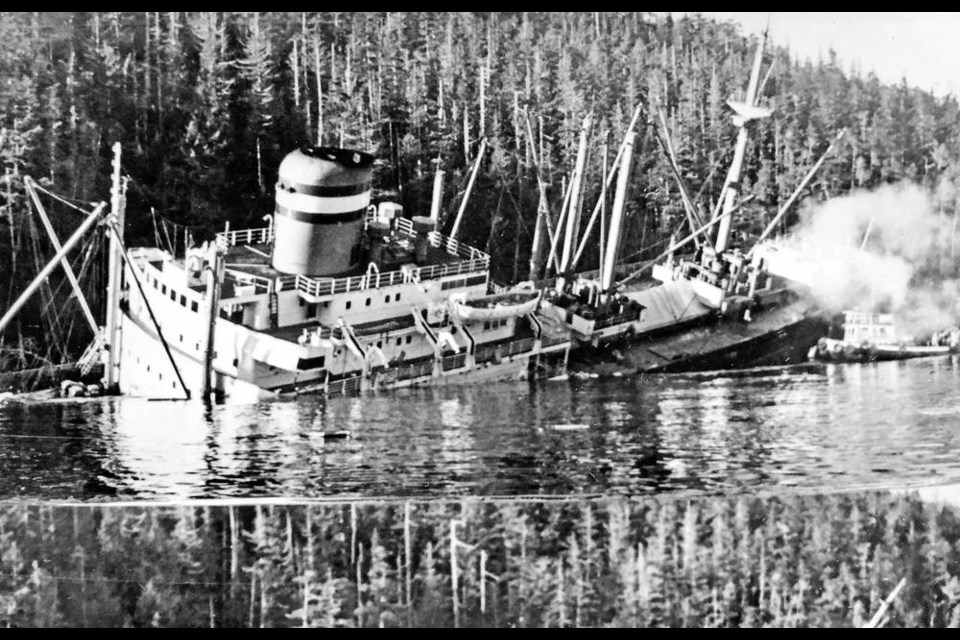
The Canadian Coast Guard said Friday it has determined the fuel is leaking from the MV Schiedyk, a 483-foot cargo ship that struck a submerged ledge and sank on Jan. 3, 1968.
The Schiedyk departed Gold River that day with a cargo of wood pulp and bulk barley en route to Portland, Oregon. It hit the ledge on the south side of Bligh Island, causing a 100-metre gash in the hull.
The 34 crew members abandoned ship and reported oil on the water, but it wasn’t clear how much of the ship’s fuel had escaped at the time.
The ship floated off the ledge and drifted down Zuciarte Channel before grounding again. Sonar indicates the shipwreck is in 360 to 400 feet of water on the east side of Bligh Island.
Kiri Westnedge of the coast guard’s incident command post said the amount of fuel on the surface is “minimal,” and a 10,000-foot boom has been deployed to contain surface pollutants to protect sensitive ecological and archeological sites.
She said the coast guard is working to assess and contain the immediate threat and prevent long-term damage to the environment, including deploying a remotely operated vehicle to see the condition of the shipwreck and, if possible, to get an idea of how much fuel is still on board.
A video of the hull taken by remote cameras on Wednesday shows a thick fluid, likely bunker oil, flowing out of the hull in a hair-like stream.
Westnedge said pandemic protocols and winter storms are limiting immediate action on potential repairs to the wreck.
Rrepresentatives of Mowachat/Muchalaht, Hesquiaht, Ehattesaht Chinehkint First Nations and the Nuu-Chah-Nulth Tribal Council are providing local knowledge about the area, and identifying sensitive ecological and archaeological sites.
The amount of fuel coming from the wreck is estimated at 30 to 50 litres. Samples are being collected to confirm the type of fuel.
Tyler Yager, a deputy superintendent with the coast guard’s emergency response unit, confirmed the wreck contains bunker oil, diesel and likely other fuels. He said the ship is upside down on the bottom.
Air surveillance of the area is underway using drones and overflights by Transport Canada aircraft to assess the spread and direction of marine pollution. A Fisheries and Oceans team is also being dispatched to survey the area for potentially affected mammals.
The effort also includes gathering historic information on the MV Schiedyk, including fuel capacity, location of fuel tanks and the original reports of the shipwreck, Westnedge said.
“Once the command has made these assessments and taken initial action to protect sensitive areas, longer term strategies and tactics will be developed for containment and protection, and ongoing information gathering will determine the action plan,” the coast guard said in a statement, adding on-site operations are dependent on weather and sea conditions in the area as work progresses.
Bligh Island, which is within the traditional territory of the Mowachaht/Muchalaht First Nation, is in the Spanish Pilot Group of Islands, a popular recreational destination for anglers, boaters and kayakers.


