A scientific exploration of the area’s ancient history continues to unearth evidence of settlements throughout the region. Tla’Amin (Sliammon) First Nation and Simon Fraser University are in the fourth year of a collaborative heritage program that is systematically creating a picture of the rich and sophisticated culture of the ancient people who populated the coast.
While Tla’Amin members have extensive oral knowledge of their history, the area was largely unexplored from an archaeological perspective, until the Tla’Amin-SFU Archaeology and Heritage Stewardship Program launched in 2008. The project brings together oral traditions with information from archaeological field work conducted in the summer and archival investigations.
In the initial years, one of the areas archaeologists studied was Scuttle Bay (Kleh Kwa Num). Knowledge from Tla’Amin elders indicated the bay was used to gather and process foods such as herring and Saskatoon berries, a place to take refuge during conflict and a place to live. Excavations at Scuttle Bay in 2008 and 2009 yielded stone and bone artifacts, the remains of plant and animal foods, indications of numerous longhouses and a “petroglyph” (pecked boulder).
Over the past three field seasons, archaeologists have located a large number of pre-recorded and unrecorded sites in Desolation Sound as well. The site includes major and minor residential settlements, refuges, lookouts, fish traps, clam gardens, and pictographs.
The group has returned to Cochrane Bay (Ke’kegish) to continue the excavation of semi-subterranean structures. Initial testing, excavation and mapping of the site in 2009 and 2010 revealed that it is roughly 4,000 years old, but the semi-subterranean structures were likely built about 800 years ago. The testing also found that granite cobbles and slabs were used as architectural elements within the largest of the structures and one of the smaller ones at the site.
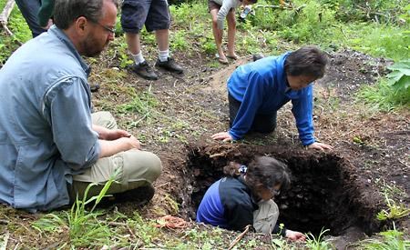
This year, the scientists have included Harwood Island (Ahgykson) in their work. Chris Springer, a doctoral candidate in SFU’s archaeology department, is studying a site on the south side of the island facing Blubber Bay on Texada Island, another large village site in the past. From the beach, the Harwood site extends about 80 to 90 metres back into the woods and is about 120 metres across. “Up on the bluffs, you can see everywhere,” said Springer. “It’s an amazing view.”
The archaeologists have found five cultural depressions in the ground that may have been structures at one point. “We’ve excavated into three of them,” Springer explained. “In one, just below the litter mat, there’s about 40 to 50 centimetres of shell midden. Below that there is a layer of fire-cracked rock and black, silty loam. Below that there is a really fine silt layer mixed with clays.”
Springer thinks that earlier layer might have been a floor surface for a structure. He has had it dated and it came out to approximately 2,300 years ago.
They’ve also taken a sample to be dated from a large midden mound in between two of the depressions. “I suspect that one will be more recent, because we think there’s a shift in site use more recently, about 6oo years ago,” Springer said. “All of this shell is associated with that period. That would be consistent with other sites we have dated and looked at in other parts of the territory, where these high locations seemed to have been used around 500 to 600 years ago. Some kind of shift occurred then.”
Two of the other depressions are being excavated as well. One has no shell in it and, at about 70 centimetres down, it seems like there was some stone used in the structure itself, potentially as a post-hole support. “They’re all flat stones used on the floor. We’re hoping to get a date out of that one as well,” Springer said.
Another depression that is being excavated has revealed a few metres of litter mat and, below that, a shell layer. “I’m suspecting that below that will be the black, silty fire-cracked rock and below that, the finer silts and clays that would be an earlier use of the depression as potentially a structure of some kind. That would be the floor material.”
The evidence so far indicates that the site had structures that were being lived in, Springer said, and the structures were partly in the ground. “For some reason, this whole area has been piled up with shell,” Springer said. “As they’re living there, the debris would be building up around them.”
Then for some reason, the structures were abandoned. “Then there’s some kind of a shift,” he said. “I’m suspecting it’s going to be similar to higher up sites that are in the 600 to 500 year period.”
At the bottom of one of the excavations, the flagstone they discovered was similar to discoveries at Cochrane Bay. “Out in Desolation [Sound], we see the same kind of flooring,” said Dana Lepofsky, who, along with John Welch, leads the program. “That’s amazing. I’ve dug lots of houses and I’ve never seen flagstone flooring, except for those two places.”
The most common kind of flooring comes from just patting down the soil, Lepofsky said. “If you imagine people building an in-ground structure, there are a couple layers of flooring. Through time, they built up an edge around it, just by dumping their garbage and their waste around. It makes basically an edge and it makes an effective depression. Those depressions become a really great place for later people to just toss their stuff in.”
While part of the historical record includes information about in-ground housing, being used as a refuge, Lepofsky thinks the flooring points to other uses. “You don’t put beautiful flagstone flooring in your bunkers. These are not places where people are going to hide out just in times of conflict. There’s something more special about them.”
Finding flagstone is unusual, Lepofsky said. “We’re wondering if these are homes for more influential people who can build themselves nice homes and where people go in times of trouble. They’re actually not bunkers, but status homes. There are stories about people hiding out with influential people in times of trouble.”
The shells, mostly butter clams, but with some little necks, mussels, urchins and cockles, are nicely layered. The abundance of shells points to the sophisticated fish traps and clam gardens the archaeologists have been documenting throughout the area.
As well as recording the locations, the archaeologists have been working on breaking down fish trap structures into their elements, their basic, functional parts. “We see that there are 11 elements and the fish traps are actually a combination of these elements in different configurations, depending on the landscape,” said Lepofsky. “They’re not all for trapping. They’re for trapping and/or encouraging clams. They’re gentle modifications of the whole inter-tidal zone. What we call fish traps are actually very complicated complexes.”
The structures are found only in certain places. On Harwood, there is a long reef wall, which the scientists think was used as a combination of trapping and clearing the beach to enhance clams.
The scientists and Tla’Amin community members continue to excavate and collect shell and animal bones samples in order to better understand how Tla’Amin’s ancestors used resources to sustain large populations and how they interacted with both the physical and cultural landscape.


