RODANTHE, N.C. (AP) — Hurricane Erin kicked up big waves Thursday along the mid-Atlantic coast and began a slow march out to sea after pelting North Carolina’s Outer Banks with strong winds and swells that flooded a few places on the barrier islands.
The storm will continue to bring the threat of dangerous rip currents and coastal flooding into the weekend from the Carolinas to New England even as forecasters predict it will gradually weaken while moving farther away from the East Coast.
Damage assessments were still underway on the Outer Banks and more flooding could come during high tide Thursday evening, but it appeared the low-lying islands dodged widespread destruction during its initial brush with Erin on Wednesday.
Tropical storm warnings remained active along the coasts of North Carolina and Virginia and the island of Bermuda, where residents and tourists were told to stay out of the water through Friday.
New York and New England feel Erin's impact
Coastal communities along the mid-Atlantic and southern New England coast may see tropical-storm-force wind gusts through early Friday, according to the National Hurricane Center in Miami.
Beaches were closed to swimming Thursday in New York City, but that didn’t stop more than a dozen surfers from taking on the waves at Rockaway Beach in Queens. Scott Klossner, who lives nearby, said conditions were great for experienced surfers.
“You wait all year round for these kinds of waves. It’s challenging, really hard to stay in one place because there’s a heavy, heavy, heavy rip," he said. "But this is what surfers want — a hurricane that comes but doesn’t destroy my house? I’ll take that.”
Off Massachusetts, Nantucket Island could see waves of more than 10 feet (3 meters) this week.
Authorities up and down the coast have been warning all week that rip currents from the storm could be deadly. Dozens were rescued from North Carolina's Wrightsville Beach earlier this week.
Erin brings new threat of coastal erosion
Coastal erosion was a big worry in many beachfront communities. In North Carolina, waves were estimated as high as 18 feet (5.5 meters) Thursday morning, according to local weather reports.
The Outer Banks — essentially sand dunes sticking out of the ocean a few feet above sea level — are especially vulnerable. Storm surges can cut through the dunes, washing tons of sand and debris onto the road and sometimes breaking up pavement and creating new inlets.
But Dare County Manager Bobby Outten said one of their worst fears — new inlets — had not happened so far with Erin and there was no significant structural damage to any homes or businesses.
“All in all, it’s not as bad as it could have been,” Outten said. “Hopefully the worst of it is behind us.”
The Hatteras Island Rescue Squad, a volunteer group based in Buxton, said it received no calls for rescues Wednesday night through Thursday morning.
Waves did break through dunes on Hatteras and Ocracoke Islands, closing parts of Highway 12, the area's main route. Ocracoke’s connection to its ferry terminal was cut off.
Fishing and sight-seeing after the storm
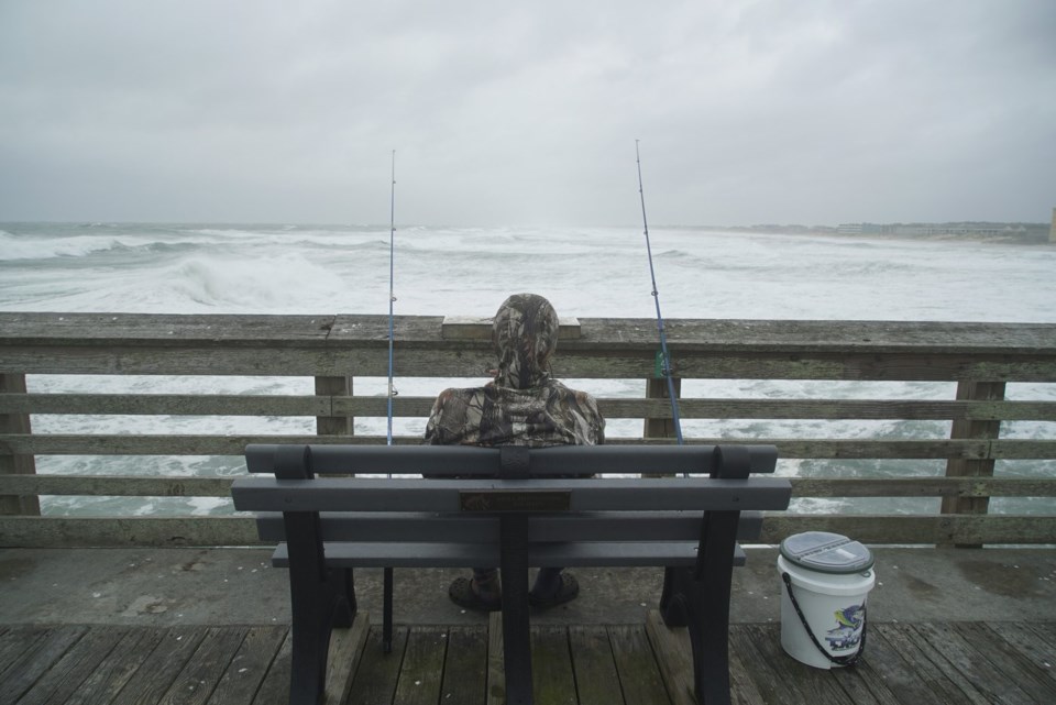
On Jennette’s Pier in Nags Head, where sustained winds reached 45 mph (72 kph) early Thursday, dozens who rode out the storm were taking photos of the huge waves crashing into the structure amid the driving rain.
“This is nature at her best,” David Alan Harvey of Nags Head said Thursday morning. “I love this. I love these storms.”
A few feet away, Sebastian Kettner was casting a line for red fish.
“Where there's water, there's fish,” he said as the wind howled. “And there's a lot of water here.”
Erin remains a large hurricane as it heads out to sea
The storm has fluctuated in intensity since first forming nearly a week ago, but it's still unusually large, stretching across more than 600 miles (965 kilometers) — twice as big as the average hurricane.
It remained a Category 2 storm late Thursday morning with maximum sustained winds around 100 mph (160 kph), the hurricane center said. Erin was about 285 miles (455 kilometers) east of Cape Hatteras.
The hurricane center was also watching two tropical disturbances far out in the Atlantic. With thousands of miles of warm ocean water, hurricanes known as Cape Verde storms are some of the most dangerous to North America.
___
Seewer reported from Toledo, Ohio. Associated Press journalists Tammy Webber in Fenton, Michigan; Jeffrey Collins in Columbia, South Carolina; Kathy McCormack in Concord, New Hampshire; and Julie Walker in New York contributed to this report.
Allen G. Breed And John Seewer, The Associated Press


