A new edition of the popular Sunshine Coast Trail (SCT) guidebook by Eagle Walz contains information about 10 shelters along the 180-kilometre route. With the addition of the shelters, the SCT claims the title of Canada’s longest hut-to-hut hiking trail.
Walz is launching the book at 6:45 pm on Thursday, April 11 at Breakwater Books and Coffee with mingling and refreshments. After 7 pm he will give a short talk and present a slide show on the huts of the SCT. The presentation will be followed by a question and answer session and then the book signing.
“I believe people will enjoy reading about the shelters,” said Walz. “Their addition to the trail has raised its profile throughout the world.”
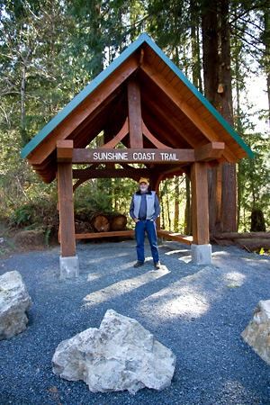
The shelters, which were built entirely by volunteer labour, are located at Manzanita Bluff, Rieveley Pond, Fiddlehead Landing, Tin Hat Mountain, Elk Lake, Walt Hill, Mount Troubridge, Rainy Day Lake, Fairview Bay, plus the Welcome Kiosk at the SCT Saltery Bay trailhead parking lot. The book also describes three other huts and a picnic shelter that were already established before the start of a project to enhance the SCT, which runs from Sarah Point in the north to Saltery Bay in the south. Two smaller huts are situated along the Inland Lake Trail, another log cabin is nestled on the shore of Confederation Lake and a picnic shelter is located at Little Sliammon Lake.
The guidebook has many new pictures, including photos of all of the new huts. There are also separate trail descriptions for each of the huts. For the through-hiker there is a trekker’s odometer that describes what turn to take at any junction or intersection of the SCT with another trail or road. Each turn, or point of interest, has a corresponding kilometre count, down to the nearest tenth. The odometer starts at the northern trailhead at Sarah Point at KM Zero and progresses southward toward Saltery Bay. It also has symbols indicating the location of huts, potable water, picnic tables, tent sites, pit toilets, points of interest, parking areas, swimming holes etc. This edition also has more GPS waypoints to help hikers navigate safely.
In 2009 the Powell River Parks and Wilderness Society (PRPAWS) received a grant of $160,000 from Island Coastal Economic Trust (ICET) that paid for the materials and transportation to the often-remote building sites. Over the last four years, the PRPAWS construction crew received support from members of Rotary Club of Powell River, BOMB (Bloody Old Men’s Brigade) Squad and Powell River ATV Club, as well as from other individuals. During this time, PRPAWS and friends have worked well in excess of 11,000 hours, which has generated the required matching funds for the ICET grant.
The use of the huts is free, but when visiting them, hikers are encouraged to make an entry in the log books to show the many different places they come from and the experience they are having at the huts and on the SCT.


